Wednesday, November 7, 2012

Three Forks - November 1, 2012


Three Forks.  The name refers to the junction of Holcomb, Overflow, and Big Creeks which combine to form the West Branch of the Chattooga River.  The rocky junction, surrounded by rapids, falls, rocks and foliage, is truly beautiful and a great setting for lunch.  We started with a small stream crossing with some choosing to shimmy across a large log instead of jumping rocks.  The trek out and back totaled 6.7 miles.  It's mostly moderate, except for a short, steep decent as we neared the forks.  The scramble in and out was definitely worth the brief effort.


 A bit chilly this am!


DIRECTIONS:  Head north on SC28 for 16.5 miles into GA.  Another 6.5 miles north of Russell Bridge (the SC/GA border) look for a clearing on the left.  It's just uphill past a modest bridge/valley dip across a feeder of Big Creek.  Park there. There are no fees and no potties past Walhalla. 

Thursday, October 25, 2012

Scaly Mountain - Highlands, NC

I hiked this part of the Bartram trail last May, but I'll hike anywhere, anytime I get a chance. We had 15 of us today for a 5.5 moderate hike.   I was a bit concerned about this trail because it was mostly uphill and I new my left knee can cause me problems on the descend.  Taking some Advil and eating my banana must have some benefits because it was a breeze on the downward trek.  No problems with that.  However, I did experience some sort of anxiety attack at the beginning of the hike.  I needed to fall back just as we started and do my business (note to self - don't drink a lot of coffee before heading to the woods).  I got a bit confused where the trail went and thought I was lost.  I really didn't want to blow the whistle and cause commotion so I finally figured it out and caught up with the group.  It took me 3 miles into the hike before I could control my heavy breathing and my chest to stop hurting.  I was so nervous.  All ended well.  The leaves were spectacular and you couldn't have asked for more perfect weather.

View from Summit
My app on Droid said I'm looking at Grassy Knob???

Spectacular vistas

It does say "Most Difficult" but it is a slow incline.

View from Osage Parking Area - off 106 Highlands


A nice treat on the side trail....

Sloan Bridge to Whitewater Falls

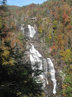
After two weeks of not being out in the woods, it felt so good to get out today.  Fourteen of us gather at the Sloan Bridge Foothills access off Hwy. 107 in SC to hike 5 miles to Whitewater Falls.  Temperature was 50ish early in the am, but it didn't take long to warm up to the mid 70's by lunch.  We started out on the Foothills trail for aways crossing the SC-NC state line leaving Nantahala National Forest and entered Sumter National Forest then took the spur trail towards Round Mountain.  Several campsite areas and water sources along this section.  The trail then crosses NC 281 and enters woods again for a short ways to Whitewater Falls.


Sunday, October 7, 2012

Whiteside Mountain

Whiteside Mountain (4,930 ft) in North Carolina, between Cashiers and Highlands offers stunning views of the transition from the Blue Ridge Mountains to the Piedmont of South Carolina. 


There are two ways to hike this area.  The easier route is on an old road bed.  Our group treked up the more challenging trail.  The first mile of the hike consist of the initial climb up the back north side of the mountain via the steps, stairs and boards walks.  Eventually the trail will turn and traverse along the top of the cliff with continuous views toward the south.  The trail peaks out at the summit and continues along the cliff top until a concrete platform.  At the platform there are excellent views back toward the cliff as well as toward the south.  Our group continued on to have lunch at Devil's Courthouse.  If I hadn't been with the group, I doubt I would have found my way to this part of the mountain.


Whiteside Mtn from Chimney Top Mtn near Cashiers NC
Devil's Courthouse small rock peak on Right Side of Mtn.


The trail head is located between Highlands and Cashiers NC.  From US 64/ NC 107 highway intersection in Cashiers NC, head west on US 64.  After approximately 6 miles the road climbs and tops out at a stunning view toward the east (left).  The road then turns sharply to the right at the Jackson/Macon county line.  Just after the county line take the immediate left onto Whiteside Mountain Road.    Parking costs $2 per car.


Do one seemed to know the name of this waterfall.
It's on the more rouged trail coming down the mountain.

The beginning of Fall colors


End of hike - exiting the trail from the back side of the parking lot. 

Friday, September 28, 2012

Licklog and Pigpen Falls - Chattooga River

Waterfall Trail


Licklog & Pigpen Falls


   Description: From Walhalla, drive 8.2 miles N on SC28, then 6.5 miles N on SC107 taking a right turn at Cheohee Rd.  The Foothill Trail picks up across SC107. You will hike the Foothills Trail for  approx. 2.5 miles and come to a clearing and the falls of Pigpen.   Cross the footbridge to continue for .2 mile on the Chattooga Trail and the first level of Licklog Falls will be to the right of the trail.  The second level is approximately 50 yards downstream of the first.  Continuing on a short distance, you will come to the Chattooga River.

.  
The 80-foot Licklog Falls and the Pigpen Falls are much prettier than their names imply. Interestingly, these two falls are among five waterfalls you could visit by hiking the entire Chattooga Trail, which should emphasize the steep and wild nature of this terrain. Even so, this is an ideal area for a family outing.
ou outing.
 .


Height: Pigpen is 25 feet. Licklog’s first level is 30 feet and second level is 50 feet .

Creek or river: Licklog Creek and Chattooga River

USGS Quadrangle: Satolah and Tamassee


We had 7 hikers today and such beautiful weather.  I was concerned whether I would have knee problems today, but all was well.  I remembered to take two Advil and my banana before I left the house this am.  The treking poles probably helped as well.


Pigpen Falls

Rest Time at Chattooga River

Licklog Falls - Tried to get closer, but terrian is a bit steep!

Picnic Time


Thursday, September 20, 2012

Beginning of 2012-2013 Hiking Season (Yellow Branch)


Yellow Branch Falls

(Oconee County)


What a beautiful day for the first hike of the season.  We began by gathering at the Keowee Key Parking Area to meet the new comers and to send farewell wishes to Sue Miyano.  Sue is moving to Washington after living in Keowee for 20 years.  She has also been hiking for those 20 years with the group.  Sue will certainly be missed.  She was so kind to leave me a few hiking books, maps and several other materials that will come in handy on the trails.


Sue


We met our next group in Walhalla to regroup and head to Yellow Branch.  I believe there were 25 of us today.  The description below is not to accurate to what I found.  This is an easy  in and out hike.  The trail had seen some harsh winds so there were alot of down trees that blocked the trail.  Alot of over and under hiking today.  The best part of the hike was the falls.  We just had a few days of hard rain, so there was a little bit of water coming over.  Love to jump over the rocks in the creek and walk thru it in my Keens. 


DESCRIPTION:       This moderately difficult out-and-back trail leads you to the base of a spectacular 50-foot vertical cascade. Starting from the parking area, you will hike approximately .2 mile on the Yellow Branch Nature Trail, before you come to the junction with the Yellow Branch Falls Trail. You will pass through groves of dignified hardwoods and cross meandering creek bottoms before turning to circumnavigate the steep terrain. In the winter when the trees are bare, you can see the Walhalla vicinity as you hike. Wear sturdy shoes and use extra caution during wet conditions as this trail skirts the edges of deep ravines. Conversely, if it hasn’t rained for some time, the falls may be just a trickle of water over a series of ledges.


Height: 50 feet


Length of hike: 1.3 miles in addition to the 0.2 mile on the Nature Trail (either direction)


Time to hike: 1 hour


Difficulty: Easy - Moderate


Creek or river: Yellow Branch


USGS Quadrangle: Whetstone


Directions to the falls:


1. From Walhalla drive west on SC 28 for 6.8 miles and left turn into Yellow Branch Picnic Ground (open 6 a.m. to 10 p.m. year round).

2. Hike in 0.2 mile on the Nature Trail (from either end) to the Yellow Branch Falls Trail.

3. Hike 1.3 miles to the falls.  


Wednesday, July 11, 2012

Lower Whitewater Falls

Enjoyed a wonderful hike today with Pam to see the Lower Whitewater Falls.  Entering in from the Bad Creek Parking lot in SC, we made our way crossing the bridge on the Whitewater River and proceeding to the spur trail.  Neither one of us had seen this waterfall and was totally taken by surprise to find this is a separate waterfall from the Upper Whitewater Falls in NC.  We both we're thinking the lower falls meant being at the bottom of the upper falls.  It was well worth the 4 miles in and out.  On our next expedition, we'll go in again at Bad Creek and follow the Foothills trail to see the Upper Falls. 

Wednesday, June 27, 2012

Keowee-Toxaway State Park with Pam

Even though the hiking group has ended their hikes for the summer months, Pam and I are continuing on Tuesday's around the area.  If we get a good early start, we can be on and off the trail by lunch.  Today we visited Keowee-Toxaway State Park just a few miles from my house.  Pam brought Penny again and also her neighbor, Kim.  Kim had hiked alot before she moved here.


Starting at parking area, we headed to the Natural Bridge Trail about .5 miles before we connected with the Raven Rock Trail.  This trail is moderately strenuous and it's a 4.2 mile loop.

Pam checking out the water running under the boulders to the other side.


Kim and I were checking out this guy just a few feet away.  Not sure what kind he is.....couldn't see his tail because of the leaves.  Could it have been a rattler?  He wasn't moving.


Our journey today lead us around McKinney Mountain to a beautful area on the north end of Lake Keowee.  I believe this area is on the route to the "Boathouse" restaurant if you were traveling by boat.   It was a good descent to the lake shore.  We kept hearing noises just before here and found that there were aleast 6 convicts working on part of the trail. 


I was here!


Just a brief break before we start back to re-connect to the Natural Bridge Trail.


Another break for a picnic just at the junction.  Very peaceful spot!  It was a good day for hiking. 


Tuesday, June 26, 2012

To Table Rock State Park with Pam

So glad to get back on the trail today......we didn't let the heat get the best of us. Got a fairly early start with the temps expecting to reach the low 90's.


Can't hike in this weather without the Deet!


Started out on the loop of the Carrick Creek Nature Trail - about a 2 miles.  Such a beautiful trail that follows the creek a good ways.  You can connect on the route to the Table Rock Trail, Pinnacle Mountain Trail and the Foothills Trail along this area.  Think will try the Pinnacle Trail on another day.  It is suppose to have a waterfall and an overlook on the way up.


What fun to have Penny with us today.  She is so good.  Most of time she is off the leash.


Beautiful place for the kids to play or just relax!


We finished this loop then made our way over to the Pinnalce Lake side where we hiked another 2 miles around the lake.  Boy, you can really see Table Rock from here.  We encounted a beautiful doe and her fawn on this trail.  I was a little worried when the doe started pawing the ground when she saw Penny!  Luckily Penny didn't see her.


View from back side of lake looking toward Table Rock!  One day we will hike to the top!


The area had started to pick up with more hikers, bikers and swimmers just as we were finishing the lake trail.  Found a nice picnic area by the lake and had a few unwelcomed vistors.


Time to go.......and we ventured back to Hwy. 11 heading North to see if we could find a Vineyard I had heard about.


Believe we found it!

We were so impressed to have found such a treat at the Victoria Valley Vineyards, I decided this was where I wanted to come for my Birthday Dinner and so we did.......